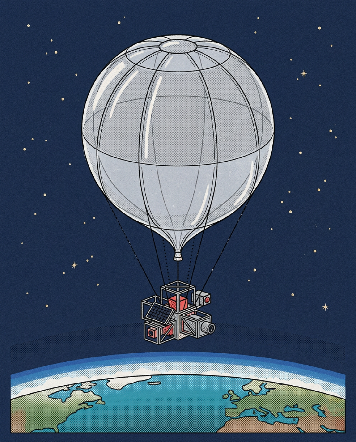

Building a startup in the hardware and aerospace sector is notoriously difficult. Most founders shy away from it because the capital requirements are high and the physics are unforgiving. However, Near Space Labs has taken a different approach to capturing Earth imagery that avoids the massive costs of launching satellites and the logistical headaches of piloted aircraft. Their solution focuses on the stratosphere, which is the layer of the atmosphere about 60,000 to 90,000 feet above the ground. By operating in this specific zone, they can capture data that is much more detailed than what a satellite can see, while covering more ground than a traditional airplane can in a single flight.
The core of their technology involves small, automated balloons they call Swiftys. These are not the massive weather balloons you might be thinking of. They are robotic platforms designed to be launched easily and often. They drift through the stratosphere and use high-end sensors to take photos of the ground. Because they are closer to the Earth than a satellite, the images are incredibly sharp. Because they are higher than a plane, they do not have to worry about traditional air traffic patterns in the same way. This allows them to provide frequent updates to maps and data sets, which is exactly what a lot of businesses need right now.
The Team and the Market Problem
#The company was founded by Rema Matevosyan, who serves as the CEO, and Ignasi Lluch, the CTO. Their background is deeply rooted in the technical side of aerospace and data. When you look at their trajectory, it is clear they identified a massive gap in how we look at our planet. Currently, if you want a picture of a specific city or a farm, you usually have two choices. You can buy satellite imagery, which is often blocked by clouds or lacks the resolution to see fine details like roof damage or sidewalk cracks. Alternatively, you can hire a pilot to fly a plane with a camera. Flying a plane is expensive, burns a lot of fuel, and takes a long time to coordinate.
Near Space Labs is targeting a market that needs both high resolution and high frequency. This includes urban planners who need to see how a city is changing week by week, or insurance companies that need to assess property damage immediately after a storm. By using balloons, the team has managed to lower the cost of data acquisition significantly. They are essentially democratizing access to high-quality geospatial information. For a founder watching this, the lesson is clear: they found a middle ground between two existing, flawed solutions and built a technology specifically for that gap.
Comparison to Existing Solutions
#To understand why this matters, you have to look at the competition. Traditional satellite companies like Maxar or Planet Labs have hundreds of millions of dollars in orbit. Their satellites move fast and cover the whole globe, but they are limited by the laws of optics. Being hundreds of miles away makes it hard to see the small things. Furthermore, satellites are stuck in their orbits. If a cloud is over your target, you get no data that day. Near Space Labs can launch their balloons under the clouds or wait for a clear window with much more flexibility.
On the other end of the spectrum are drone operators and aerial survey companies. Drones are great for a single building or a small park, but they cannot cover an entire metro area in a morning. Planes can cover cities, but the cost of fuel, pilots, and maintenance makes the data expensive. Near Space Labs fits right in the center. They offer the scale of a satellite with the clarity of a plane. Their balloons are also zero emission during flight, which provides a sustainability benefit that traditional aviation cannot match. This comparison shows that they are not just making a better camera, they are changing the economics of the entire delivery system.
Specific Scenarios for Implementation
#There are several key scenarios where this type of data becomes a vital tool for decision-making. One of the most obvious is disaster response. When a hurricane or a flood hits, local infrastructure is often destroyed. Roads are blocked and it is dangerous to send people in. A fleet of Swiftys can be deployed to provide a bird’s eye view of the entire region within hours. This allows emergency services to see exactly which bridges are down or which neighborhoods are submerged without risking a pilot’s life in unstable weather.
Another scenario is in the world of construction and real estate development. If you are managing a multi-billion dollar project that spans several miles, you need to track progress. Manual inspections are slow and prone to human error. High-frequency imagery allows project managers to overlay new photos on top of blueprints to ensure everything is aligned. It also helps in identifying logistics bottlenecks before they become expensive delays. For founders in the software space, this data is the raw material. You can build AI models on top of these images to automatically detect changes, count cars in parking lots, or monitor the health of crops in a field.
Assessing Weaknesses and Mitigations
#No startup is without its hurdles, and for Near Space Labs, the primary challenge is the environment they operate in. The stratosphere is a harsh place with extreme temperatures and unpredictable wind patterns. While their balloons are robotic, they are still somewhat at the mercy of the wind. This can make it difficult to keep a sensor over a specific point for a long period. To address this, the team focuses heavily on their flight control algorithms and launching from strategic locations. They focus on gathering data while moving rather than trying to hover perfectly.
There is also the matter of regulatory hurdles. Airspace is heavily governed by the FAA and similar bodies around the world. Operating at high altitudes requires constant coordination and compliance. The way they mitigate this is by maintaining a transparent relationship with regulators and ensuring their hardware meets all safety standards for flight and termination. For any founder in a regulated space, the key is not to fight the rules but to build a system where compliance is a core part of the product architecture. They do not treat regulations as an afterthought; they treat them as a design constraint.
The Power of Movement Over Debate
#In the startup world, it is very easy to get stuck in the board room debating if a technology will work or if the market is ready. Near Space Labs succeeds because they focus on movement. Every launch is a data point. Every failed flight is a lesson in engineering. They are not waiting for the perfect global satellite network to be built. They are launching what they have right now to solve problems today. This bias toward action is what separates a company that builds from a company that just plans.
There are still many unknowns. We do not know how far the cost of balloon components can drop or how the global market for high-frequency data will evolve over the next decade. However, by being in the air and delivering images to customers, the team is learning things that a debate could never reveal. They are proving that you do not need a billion dollars to see the world clearly. For the aspiring entrepreneur, this is the ultimate validation. You can start with a simple idea, move into a difficult field like aerospace, and create real value by simply refusing to stop building. The stratosphere is no longer just for government agencies; it is a laboratory for startups willing to take the risk.